Flooding threat for region after cyclone packs punch
Source: BOM
A major flooding emergency is unfolding in the wake of Cyclone Alfred as a “phenomenal” amount of rain falls across southeast Queensland and northern NSW.
The same communities that had braced for Alfred were going underwater late Sunday amid relentless torrential rainfall.
Despite the cyclone weakening into a trough, the weather system continued to hang around and dump bucketloads.
A severe weather warning was in place in southeast Qld on Monday for a vast region from Gympie to Coolangatta, and inland to Toowoomba.
In NSW, the warning area stretched inland from Tweed Heads to Tamworth.
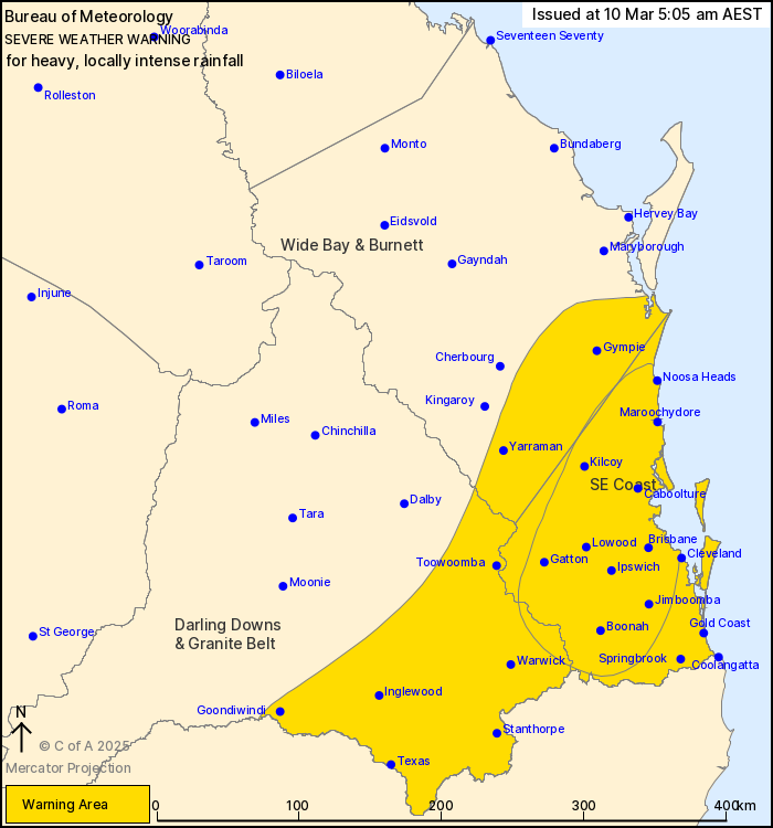
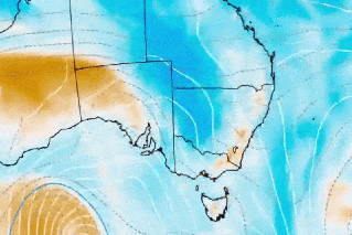
A severe weather warning in Queensland on Monday morning. Photo: BOM
Hundreds of millimetres fell on Brisbane on Sunday and the incessant rain was still pouring from the skies into Monday morning, with up to 150 millimetres more expected.
Creeks broke their banks, roads were covered and water lapped at houses amid warnings of dangerous and potentially life-threatening flooding.
Localised heavy rainfall also smashed parts of the Gold Coast, Sunshine Coast and NSW’s Northern Rivers.
More than 250,000 households across the southeast were without power on Monday, which Premier David Crisafulli said was the highest number without power in a natural disaster in Queensland’s history.
Trees and branches falling on powerlines from the strong winds that lashed the cyclone impact zones left entire suburbs in the dark.
But even as the winds died down, the rain did not cease.
The bureau predicted up to 150 millimetres could fall on localised areas on Monday after already copping hundreds of millimetres on Sunday.
One of the highest rainfalls was at Kingsholme, in the Gold Coast hinterland, which recorded 205 millimetres over a six-hour period on Sunday.
Source: TND
Major flood warnings were in place on Monday morning (AEDT) for multiple rivers, with people urged to “get to higher ground”.
They included Ipswich’s Bremer River and Warrill Creek, Laidley Creek in the Lockyer Valley and the Logan and Albert Rivers near Brisbane.
In northern NSW, warnings were in place for the Tweed and Clarence rivers, which could experience potentially major flooding.
“We recommend that everyone try to get as high as they can,” said the BOM.
There were also severe thunderstorm warnings on Monday morning for separate storm cells veering towards the Sunshine Coast hinterland and Brisbane.
“Heavy rainfall which may lead to flash flooding continues across the southeast coast this morning, including Brisbane, Ipswich and the Sunshine Coast,” stated the BOM’s 5am bulletin on Monday.
“Six-hourly rainfall totals between 80 and 120 millimetres are likely throughout today. 24-hourly totals up to 150 millimetres are likely.”
Some localised areas could be hit with as much as 150 millimetres in six hours on Monday.
Parts of Gold Coast received an emergency warning late on Sunday, with communities told to “take action now” and stay off the roads.
“If you are near floodwater, you may need to get up as high as you can to survive,” it said.
On Sunday, residents at Hervey Bay north of Brisbane were told to stay inside under an emergency declaration after almost 250 millimetres of rain fell in hours, triggering flash flooding.
About 30 rescues took place across Queensland’s southeast and northern NSW.
But some were not so fortunate with confirmation a body had been found, believed to be a 61-year-old man after his ute was swept into floodwaters at Megan, near Dorrigo, NSW on Friday.
A severe weather warning was current from Hervey Bay down to NSW’s northwest.
The region is bracing for damaging winds, dangerous surf and 24 hour rainfall totals of up to 100mm leading to flooding.
-with AAP
Want to see more stories from The New Daily in your Google search results?
- Click here to set The New Daily as a preferred source.
- Tick the box next to "The New Daily". That's it.