State on first cyclone watch in more than three decades
Source: X/Ray_vff
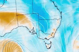
A cyclone watch has been issued for NSW for the first time in more than three decades – with “damaging” wind, waves, and possible “intense” rainfall on the way.
Tropical Cyclone Alfred is expected to make landfall in south-eastern Queensland on Thursday, with its effects felt as far south as NSW.
“This is unusual for NSW … We don’t often have tropical cyclones watches and warnings in the NSW jurisdiction,” Bureau of Meteorology manager hazard preparedness Steven Bernasconi said on Monday morning.
It is the first time there has been a cyclone watch issued for NSW since Cyclone Nancy in 1990. Before that, the most recent is Cyclone Zoe in 1974 – also the last cyclone to cross the south-east Queensland coast.
“It’s not impossible, it is unusual, and it’s important that people be ready for it,” Queensland Premier David Crisafulli told ABC Radio Brisbane on Monday.
As the warnings ramped up on Monday, there were reports of supermarket shelves being stripped bare with a wave of panic buying of household basics such as water, eggs, milk and bread.
Bernasconi said there would be gale force winds in NSW within 24-48 hours as Alfred approached.
There had already been “large and powerful swells and waves” had in north-east NSW on Monday, with abnormally high tides expected on Tuesday.
Bernasconi said damaging winds were likely on the mainland from Wednesday.
“Waves are likely to be damaging as well, and we would expect a coastal hazard warning around this time,” he said.
Alfred is a category-two system sitting in the Coral Sea, about 465 kilometres north-east of Brisbane. It is heading south-east, with winds of 95km/h at the centre and gusts of up to 130 km/h.
Alfred is already affecting the coast, with waves up to 15 metres leading to significant erosion from K’Gari Island south to the Gold Coast.
Coastal erosion will continue over the next few days as the storm does a U-turn and sweeps west.
Much of the focus will be on NSW’s northern rivers region, which is only just getting back on its feet after flooding three years ago that claimed five lives and destroyed homes.
NSW Emergency Services Minister Jihad Dib assured locals the authorities were doing “everything we can” to prepare for the looming system.
“We’re cognisant of what the northern rivers have gone through and some of the trauma that they carry,” he said.
State Emergency Service Commissioner Mike Wassing on Monday urged northern rivers residents to begin sandbagging.
Source: Bureau of Meteorology
Bernasconi said abnormally high tides and rainfall should increase into Wednesday night, with the potential for “locally intense falls” on Thursday and Friday.
“Extreme winds” of 100km/h are expected by the end of the week.
Bernasconi said widespread rainfalls of 100-300 millimetres were expected on Thursday and Friday.
There are flood watches for rivers from Maryborough, in Queensland’s Wide Bay region, south to the NSW border.
The weather bureau will also watch the Mary, Noosa, Brisbane, Logan and Albert rivers for major rises this week.
Crisafulli’s main concern was flooding across south-eastern Queensland, which is home to more than three million residents.
“When you’re talking about falls of a few hundred millimetres or more in a short period of time in already soaked catchments that will be a challenge,” he said.
“I’ve got every faith that people will get through. I’ve seen how well the south-east has handled flooding events in recent years.
“This is an added complexity, but it’s nothing that the community can’t get through.”
He urged all south-east Queenslanders to be prepared by compiling important documents, having tinned food and water and tying down any loose items outside.
Source: Australian Maritime Safety Authority
Coral Sea rescue
Elsewhere, a Lithuanian rower is receiving medical treatment on a navy ship after being rescued from damaging winds and monster waves in the Coral Sea.
Aurimas Mockus called for help on Friday when Tropical Cyclone Alfred proved too powerful as he was attempting to row 12,000 kilometres across the Pacific Ocean from San Diego to Brisbane.
The Australian Maritime Safety Authority called in the Australian Defence Force for help locate Mockus, who was stranded about 740 kilometres east of Mackay off the Queensland coast.
A Royal Australian Air Force P-8A Poseidon aircraft was sent from RAAF Base Edinburgh in South Australia and Royal Australian Navy ship HMAS Choules from Brisbane to help with the search.
HMAS Choules arrived at Mockus’ remote location about 6.30am local time on Monday.
“The solo sailor has been rescued and is safely on board HMAS Choules undergoing a medical assessment,” Vice Admiral Justin Jones said.
The ship is on its way back to Fleet Base East at HMAS Kuttabul Sydney.
-with AAP
Want to see more stories from The New Daily in your Google search results?
- Click here to set The New Daily as a preferred source.
- Tick the box next to "The New Daily". That's it.