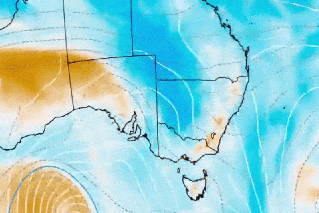
Huge line of severe thunderstorms heading across NSW
Source: BOM
Towns and cities across the entire NSW coast are in the firing line of severe thunderstorms predicted on Tuesday afternoon — just a day after a similar thunderstorm smashed Sydney.
The weather bureau has issued a warning for a “whole new severe thunderstorm outbreak” that could roll across NSW between 2pm and 8pm.
The dangerous and vast system, which began brewing around 11am, could bring another round of damage, destruction and flash flooding to communities in its path.
The warning zone stretches from NSW’s southern border with Victoria to its northern border with Queensland.
But the area expected to be worst affected encompasses the region around Dubbo, Tamworth and Narrabri on the mid-north coast.
Sydney could also be in line for another severe thunderstorm after it was smashed on Monday afternoon by a massive line of dangerous storms.
Twenty-one people had to be rescued from their vehicles in flash flooding when the storm unleashed between noon and 2pm on Monday.
Suburbs across the city flooded after up to 80 millimetres of rain was dumped in less than an hour.
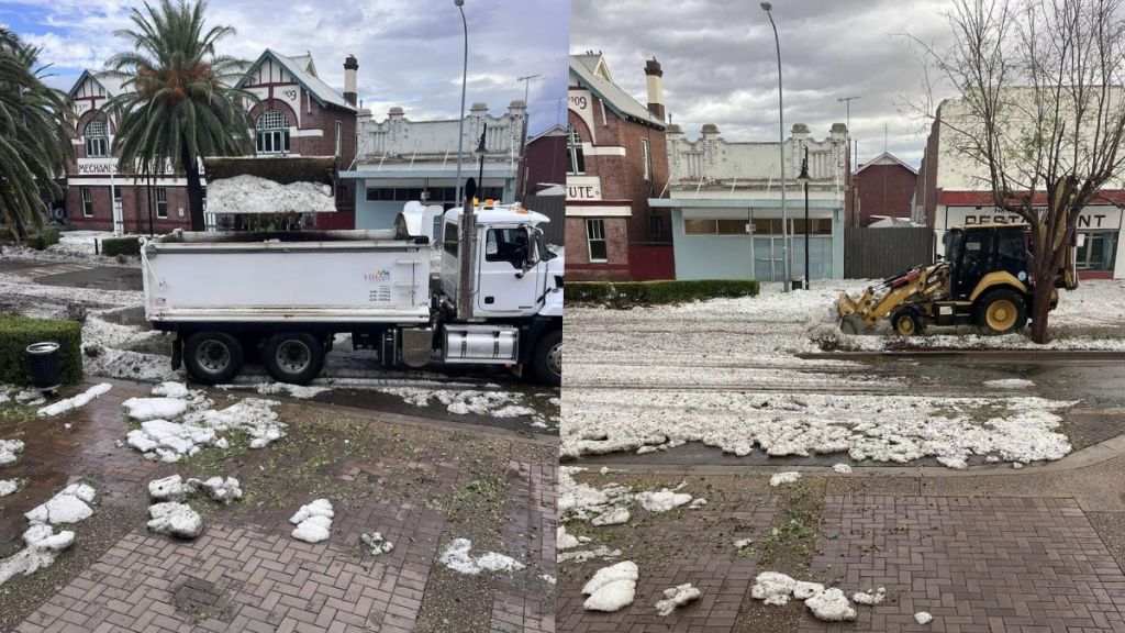
Cleaning up in Harden, NSW, after a wild storm hit early on Monday.
Bureau meteorologist Angus Hines said Tuesday could see another round of wild weather.
“Once we get into the afternoon hours — 2pm, 3pm through until 8pm this evening — looks to be prime time for that storm to develop,” he said.
“We’re likely to see an array of severe weather impacts — mostly in relation to rainfall generating flash flooding which can close roads and cause detours, delays and traffic and potentially the flooding could inundate homes, property and businesses too,” he said.
“With damaging wind and large hail we could see damage to property, crops and vehicles where the severe storms develop.”
Hines said the severe thunderstorm trend could continue on Wednesday in the north of the state from Port Macquarie to Byron Bay and pushing over the border into southern Queensland.
More NQ flooding
Life-threatening flooding and heavy rainfall are forecast for Queensland’s Northern Goldfields up to the Cape York Peninsula, down to the north Tropical Coast and into the Burdekin region.
The Bureau of Meteorology issued a severe weather warning for the large swathe of Queensland.
Rainfall totals over six hours could reach 150 millimetres on Tuesday and more than 200 millimetres in some areas in the next 24 hours.
Hines said the rain will start easing back from Wednesday across these saturated regions which have lost power, been cut off by floodwaters and had extensive damage.
He said showers and thunderstorms remain a daily risk near Mackay while the flash flooding threat sweeps south to the state’s southeast in the Darling Downs.
The region saw extensive rainfall in the last day with 120 millimetres recorded in Kowanyama in the state’s northwest, 188 millimetres in Rollingstone on the tropical coast and 155 millimetres at Upper Black River.
Premier David Crisafulli said hundreds of trucks have been moving in the far north overnight to help resupply flood-stricken areas.
“That’s the difference between people being able to eat today or not,” he told the Nine Network.
It may be some time before some across northern Queensland regions recover from extensive flooding.
At least six communities near the Gulf of Carpentaria are already cut off by floodwaters, with critical supplies unable to reach sodden locals via road.
The local mayor expected residents to be stranded for some time, with planes and helicopters set to help resupply remote towns.
“There’s six communities in the Gulf that rely on that transport corridor and that’s all going to be shut for some time into the future,” Etheridge Shire’s Barry Hughes told AAP.
Totals of more than 1500 millimetres have been recorded between Cardwell and Townsville over 10 days, ensuring February rainfall records have already been broken for some regions.
Ingham, north of Townsville, was one of the worst hit by the wet weather that has lashed the region in the past fortnight.
Flooding claimed the lives of two women and completely isolated the community, with power cut and food supplies dwindling at one stage.
But power was set to be restored to every Ingham household by Monday night and the Ollera Creek Bridge, a critical link that collapsed in floodwaters, was to be reopened to general traffic on Tuesday.
And Western Australia is at risk of a cyclone forming off the northwest Kimberley coast from Wednesday evening onwards.
It’s currently located near the northwestern coastline of WA.
It is set to be named Tropical Cyclone Zelia.
-with AAP
Want to see more stories from The New Daily in your Google search results?
- Click here to set The New Daily as a preferred source.
- Tick the box next to "The New Daily". That's it.