Bunker down or leave: Millions of people in storm path
Source: BOM
Cyclone Alfred appears to be on a collision course with Brisbane after making a dramatic U-turn and heading directly towards the southeast Queensland coast.
The latest weather bureau tracking map on Wednesday morning (AEDT) showed the category two storm could make a direct hit on the Queensland capital.
Millions of people across Brisbane, the Gold and Sunshine Coasts and northern NSW have been told to leave or prepare for the worst, as weather warnings triggered panic buying and a rush for sandbags.
Modelling showed 20,000 properties could be flooded in Brisbane and 6000 on the Gold Coast.
Sunshine Coast Mayor Rosanna Natoli suggested 4600 properties could be affected.
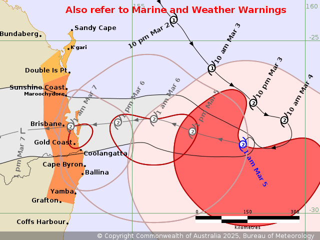
BOM’s latest tracking map shows a direct hit on Brisbane. Image: BOM
Early on Wednesday, Alfred was about 465 kilometres east of Brisbane. It is packing wind gusts of 130km/h as it travels westwards at about 11km/h.
“Alfred is a category two cyclone and is forecast to maintain this intensity as it approaches the south-east Queensland coast on Thursday,” the Bureau of Meteorology said.
A warning zone stretches from Double Island Point in Queensland to Yamba in NSW, with Alfred forecast to make landfall on Thursday or early Friday.
Flash flooding, heavy rainfall, destructive winds and storm surges will follow, as south-east Queensland faces its first cyclone direct hit in 50 years.
The worst of Alfred’s land impact is expected in Brisbane, the Gold Coast and NSW’s northern rivers – which is still recovering from deadly floods three years ago.
Prime Minister Anthony Albanese has touched down in Brisbane, as the federal disaster response plan activates and a crisis coordination team deploys.
Queensland Premier David Crisafulli said the cyclone had firmed and urged people to follow the advice of emergency personnel.
“This is a very rare event for south-east Queensland, but it’s not unprecedented, and we are asking you to take it seriously,” he said.
Rainfall totals of 100 millimetres are expected to lash Queensland’s south-east on Wednesday, with up to 400 millimetres by the time Alfred reaches land.
Schools remain open in Queensland on Wednesday but beaches, university campuses and Gold Coast theme parks will close. Ferry services have already been cancelled.
Flights are also likely to be affected.
Emergency services, telco providers and Energex crews have bolstered the region with evacuation centres on the Gold Coast open.
-with AAP
Want to see more stories from The New Daily in your Google search results?
- Click here to set The New Daily as a preferred source.
- Tick the box next to "The New Daily". That's it.