‘Severe’ rain threat as Tropical Cyclone Jasper smashes coast
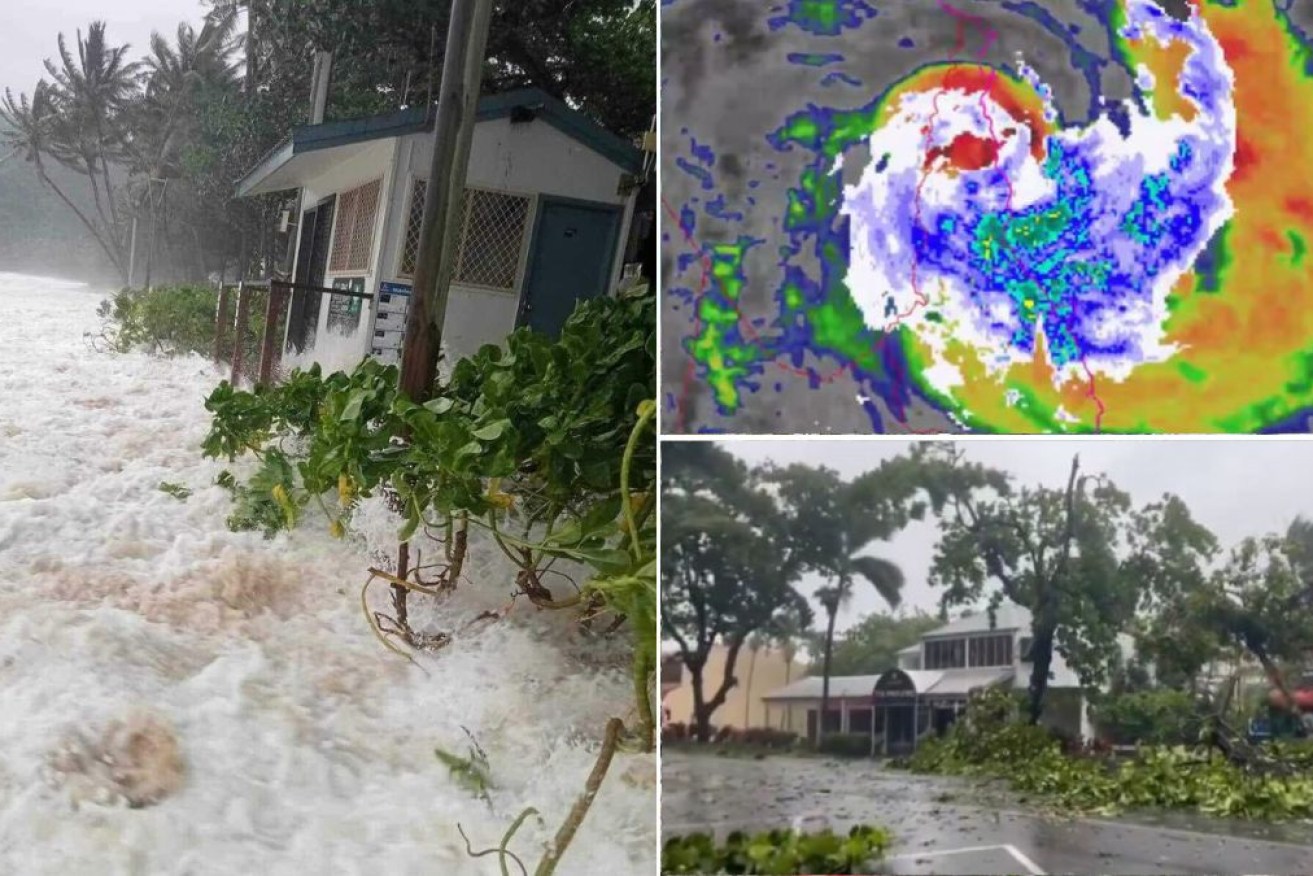
Cyclone Jasper snapped trees and brought destructive tides to Trinity Beach (left). Photo: Facebook
A severe weather warning has been issued on Thursday morning after Tropical Cyclone Jasper crossed the coast, dumping hundreds of millimetres of rain on far north Queensland communities.
Destructive winds battered the region as the category two cyclone made landfall near Cape Tribulation around 9pm Wednesday, but the full wrath was only becoming apparent as daylight arrived on Thursday.
The tropical storm snapped large trees like twigs, created damaging storm surges and brought down powerlines, leaving 35,000 homes in the dark.
After reaching land Jasper weakened and was downgraded to an ex-cyclone, but a new threat emerged as the system morphed into a slow-moving tropical low, unleashing a deluge.
A severe weather warning for potentially life-threatening flooding was issued Thursday morning as nearly 400 millimetres fell on some communities to 3am Thursday.
That was on top of some 100 millimetres that had fallen in the lead up.
“Locally intense rainfall which may lead to dangerous and life-threatening flooding is developing between Cooktown and Cairns,” said the latest BOM warning.
“Isolated six-hourly rainfall totals between 250-300 millimetres are likely with 24-hourly totals between 400-500 millimetres possible.”
Residents took shelter overnight Wednesday when Jasper crossed as a category two storm, with many evacuating their homes as winds about 100km/h uprooted trees and brought down powerlines.
The intensity of the storm was reduced to a tropical low late on Wednesday night and it was due to continue to weaken as it moved inland.
The Aboriginal community of Wujal Wujal near Cape Tribulation, lay directly in the path of the storm as it reached the coastline.
An emergency warning was in place from Cape Melville to Cardwell as the system approached the coast, with people told to stay away from big windows.
Tweet from @GeorgiHill10
“The heaviest rain is associated with these bands on the southern flank in that onshore flow,” the Bureau of Meteorology’s Sarah Scully said.
There was a risk the system could re-intensify into a tropical cyclone as it hits the Gulf of Carpentaria on Friday.
“There’s a lot of uncertainty and it’s highly dependent on how long that tropical low remains over those warm Gulf waters,” Scully said.
About 450 Energy Queensland staff were on standby at Rockhampton and Townsville while more than 100 emergency personnel were deployed out of Brisbane to boost local crews.
The Australian Defence Force was also poised to assist.
“We stand ready to support far north Queensland, the Queensland government and local governments in any way needed in the days ahead,” Federal Emergency Management Minister Murray Watt said.
Tweet from @TheTodayShow
People from Cape Flattery down to Cairns were on Wednesday afternoon told to take shelter.
“Go to the strongest, safest part of the building you are in. This will be away from big windows,” the emergency warning said.
“Stay there. Emergency services cannot get to you because it is too dangerous.”
Local cafe owner Anton Rafferty told AAP people were mainly staying off the streets in Cairns.
“For the most part, people are just sitting at home waiting it out,” he said.
Deputy Premier Steven Miles travelled to Townsville on Wednesday to monitor the emergency response.
Federal Treasurer Jim Chalmers said his thoughts were with residents bracing for impact, including his sibling.
“I’ve checked on my sister who lives in Cairns and in a typical, Queensland understated way she said it was getting a bit breezy,” he told reporters.
“I think the whole country has the people of … far north Queensland in their thoughts today as they batten the hatches.”
Evacuation centres were established in Cairns, Port Douglas and Cooktown.
Cyclone Jasper should weaken quickly as it travels inland but is expected to re-intensify as it moves into the Gulf at the weekend.
-with AAP
Want to see more stories from The New Daily in your Google search results?
- Click here to set The New Daily as a preferred source.
- Tick the box next to "The New Daily". That's it.

Landmark Islamophobia report an ‘important step’

Mount Olympus tipped for heritage list


The dangerous game that unites our politicians

Libs face old problems as Hanson holiday goes wrong