Weekend washout as heavy rain to slam eastern Australia
Weatherzone is forecasting a wet weekend on the eastern seaboard. Photo: Weatherzone/TND
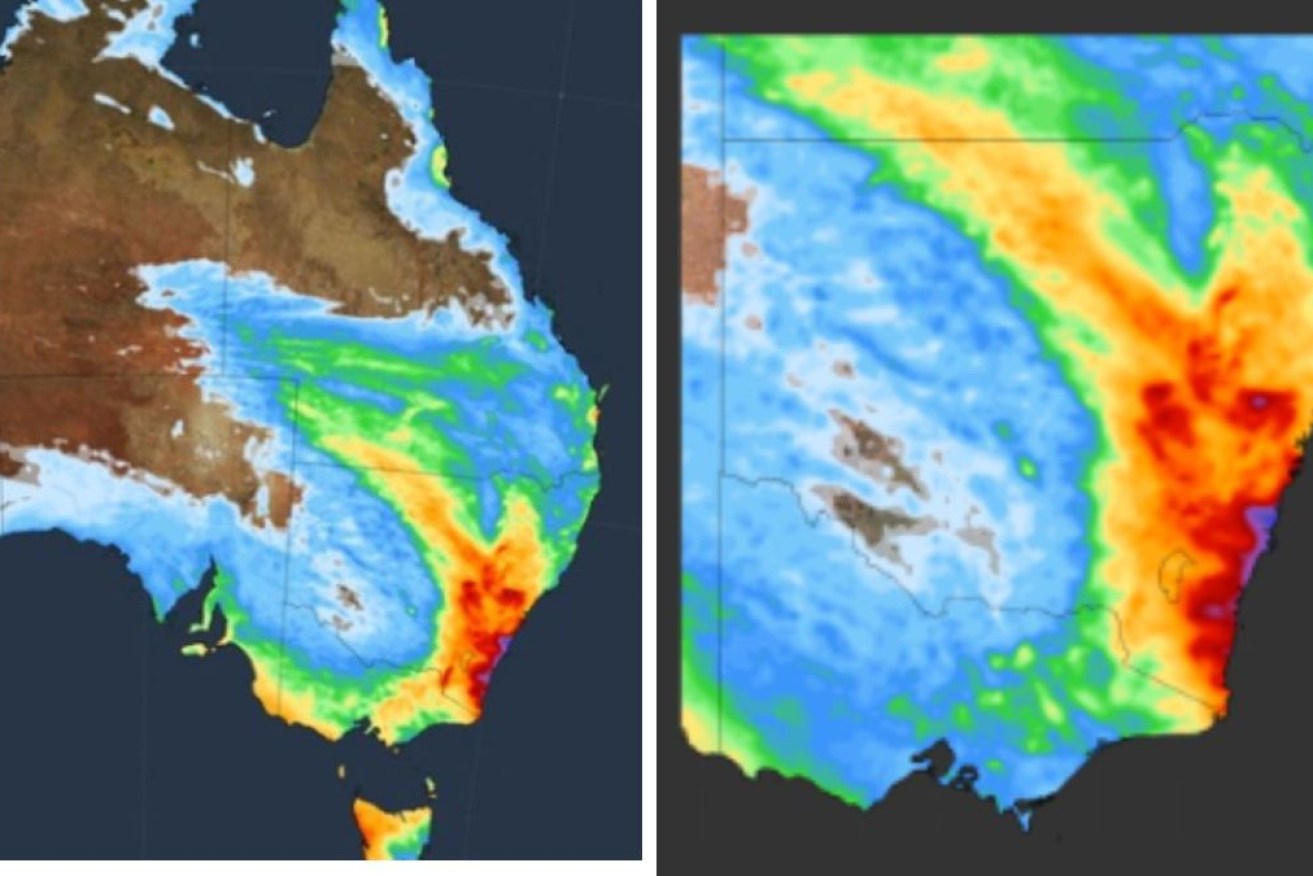
The east coast of Australia is gearing up for a drenching and thunderstorms throughout the weekend, with rain continuing into next week.
Thanks to a series to cold fronts and low pressure troughs, large areas of southern and eastern Australia will get showers and rain in the next few days, Weatherzone said on Friday.
Initially, the rainy weather will be confined to parts of southern Western Australia, South Australia, Victoria and Tasmania. However, most of those areas will have only light falls.
As the weekend gets underway, the wet weather will creep north. Rain will start to fall in NSW later on Friday and in southern Queensland on Saturday, as an upper-level trough interacts with tropical moisture.
Weatherzone said forecast models suggested the weekend deluges would be more widespread and heavier over NSW and parts of southern Queensland.
“At this stage, the heaviest rain is likely to occur in NSW between Saturday and Monday,” Weatherzone said.
“One area of particular risk for heavy rain and flooding will be the southern half of the NSW coast and adjacent ranges, where a focused stream of onshore winds could produce more than 100 millimetres of rain and possibly more than 200 millimetres in some places.”
In a bulletin on Thursday, Weatherzone said severe weather warnings, as well as alerts for floods, might be issued in eastern parts of NSW at the weekend.
Those in the area are advised to keep an eye on the latest weather warnings.
“One area of particular risk for heavy rain and flooding will be the southern half of the NSW coast and adjacent ranges,” Weatherzone said.
“Where a focused stream of onshore winds could produce more than 100 millimetres of rain and possibly more than 200 millimetres in some places.”
Tweet from @BOM_au
By Friday afternoon, the Bureau of Meteorology had issued four flood warnings for parts of Queensland:
- Moderate for Eyre Creek
- Minor for the Diamantina River, downstream of Diamantina Lakes
- Final for the Russell River
- Final for the Tully River
Tasmania was also copping brutal winds on Friday. The BOM issued a severe weather warning for damaging winds in the state’s western, Upper Derwent Valley and south-east forecast districts.
Gusts were expected to reach 100 km/h on Friday, before easing later in the day.
Tweet from @weatherzone
Weekend weather for the capitals
Sydneysiders should enjoy the sunshine on Friday, as the outlook for the weekend is grim. After a top of 27 degrees on Friday, temperatures in Sydney will only reach the low 20s on Saturday and Sunday.
Rain is expected in Sydney from Saturday until Tuesday. Canberra can also expect showers at the weekend, although the national capital’s skies are expected to clear by Tuesday.
In Melbourne, rain is expected to hang around on Saturday, but the sun should come out on Sunday. But it will be a cool weekend in Melbourne, with temperatures below 20 degrees.
Showers might increase in Brisbane on Saturday, but temperatures should remain in the mid-20s. By Sunday, expect sunshine, a bit of cloud cover with a top of 26 degrees.
Perth has the all-clear for a dry weekend, with a top of 22 forecast for Saturday and 23 on Sunday.
It will also be a dreary weekend in Adelaide, with rain persisting on Saturday and Sunday, with temperatures of less than 20 degrees.
Hobart can expect some weekend sun after Friday’s wet and windy weather. It is expected to reach 15 degrees in Tasmania’s capital on Saturday, and 19 on Sunday.
Darwin should enjoy plenty of sun this weekend, with temperatures in the low 30s for both days.
Want to see more stories from The New Daily in your Google search results?
- Click here to set The New Daily as a preferred source.
- Tick the box next to "The New Daily". That's it.


Clashes and contentious policies: Hanson at NPC

We are in a post-fact world and Hanson revels in it