East coast braces for days of wild winds, dangerous surf
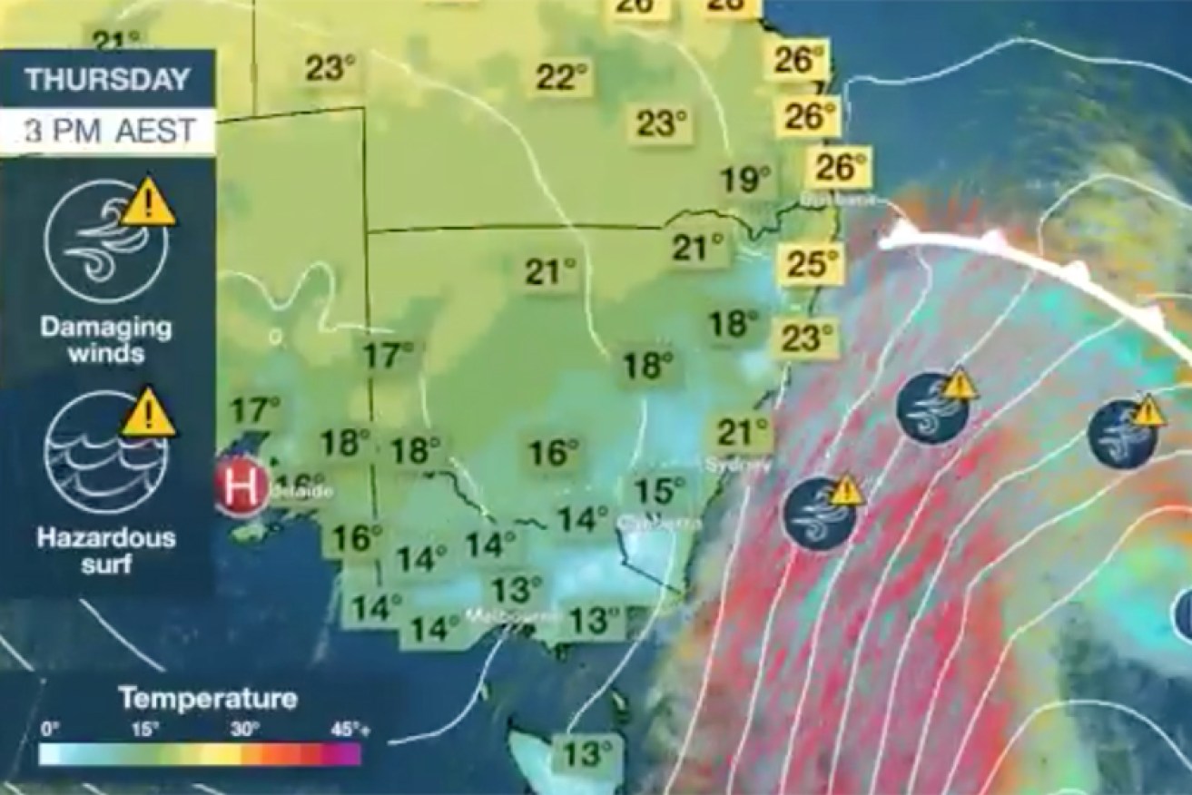
The dangerous wind and waves are unlikely to ease much until Thursday afternoon. Photo: BOM
Wind gusts of up to 100km/h and dangerous eight-metre waves are forecast as a blustery cold front bears down on thousands of kilometres of the south-eastern Australia coastline late on Wednesday.
The weather bureau has warned boat owners, skippers and rock fishers of dangerous surf conditions along much of the NSW coast.
There are also flood warnings in place for Victoria and Tasmania.
Ambulance Tasmania’s highest escalation level was triggered for the first time on Tuesday as the sheer volume of priority-one emergency calls meant every ambulance in the south of the state was either on the road or ramped at the Royal Hobart Hospital.
Surf Lifesaving NSW chief executive Steven Pearce told the Byron Echo people should consider the danger to themselves and others before they ventured into the water during the bad weather.
‘If you do see someone in danger, please call triple-zero immediately,” he said.
“Do not attempt a rescue on your own.”
Extremely hazardous swelli to 12 ft forecast for the next two days . The morning here at Sth Curl Curl Beach is lovely but already the signs of this swell are here. Stay safe !! pic.twitter.com/86TUFG1whu
— Steven Pearce (@stevenp6453) August 20, 2019
The Bureau of Meteorology said surf and high swells would develop on the NSW coast as the cold front moved north later on Wednesday.
It is expected to create hazardous conditions for rock fishing, boating and swimming along the Macquarie, Hunter, Sydney, Illawarra, Batemans and Eden coasts, the BOM said.
A marine wind warning for gale force winds is also forecast for the Eden coast and a strong wind warning is in place for Sydney closed waters, and the Macquarie, Hunter, Sydney, Illawarra and Batemans coasts.
The NSW Roads and Maritime Services has reminded boaters to take extra care and be aware of the risk of hypothermia.
Damaging winds 💨 over parts of southern and eastern #Victoria, gale to storm force winds over Bass Strait and high seas over 8 metres 🌊 are likely to accompany a cold front passing over Victoria overnight! Stay up to date with current warnings at: https://t.co/qTKz8Ik7k0 pic.twitter.com/rOErJCGezz
— Bureau of Meteorology, Victoria (@BOM_Vic) August 21, 2019
RMS also advised skippers and owners of small craft to check weather conditions before they considered crossing a coastal bar or heading offshore. Those already on the water should carry appropriate safety equipment and wear a life-jacket.
Skippers are advised to consider staying out of the water and to avoid walking near surf-exposed areas.
Rock fishermen are advised to avoid fishing near dangerous surf, to wear a life-jacket and check weather forecasts before heading out.
Outside we see a leaden sky
As clouds go zipping swiftly by
Showers come & go in town
Moreso once the sun goes down
🌧️
By Friday though a high will come
And with it comes late Winter sun
Temperatures again will rise
17 under #Melbourne skies
🌞
Details: https://t.co/EQth4njeCr pic.twitter.com/ZYUpVanLVm— Bureau of Meteorology, Victoria (@BOM_Vic) August 20, 2019
The bureau has also issued a warning for damaging winds – with gusts up to 110km/h late on Wednesday and into Thursday – for much of southern Victoria, including the Gippsland coast, Strzelecki and Otway Ranges and alpine areas above 1200 metres.
“The risk of damaging winds is expected to extend over the Mornington Peninsula, eastern parts of the Central district and the remainder of Gippsland,” the bureau said.
“Winds will ease from the west during Thursday morning and are likely to ease in the far east by late Thursday afternoon.”
A gust of 120km/h had already been recorded at Wilsons Promontory on Wednesday, and another of 96km/h at Gabo Island, in Victoria’s far north-east.
Tasmania is forecast to endure more wild winds, after gusts ripped the roof off a Hobart home on Tuesday. The island’s wild weather will not subside until Thursday, and Tasmanians have been urged to tie down trampolines until then.
SES crews are at a call out in Rosny Hill. Strong winds have torn the roof off a house, sending it up into the air, eventually dumping it into a nearby neighbour’s front yard. The neighbour was in the car with her granddaughter at the time. Nobody was hurt. @abchobart pic.twitter.com/tqRdXO8T45
— Jessica Hayes (@JessieMHayes) August 20, 2019
Gusts of 139km/h were recorded at Mount Wellington on Tuesday afternoon, and 120km/h in Hobart.
Emergency crews received multiple calls from residents in danger of losing their roofs while several trees also came down.
At Montagu Bay, a roof flew off about 5.30pm before landing in a neighbour’s property. No one was hurt.
Up to 80 millimetres of rainfall is forecast for Tasmania’s west, and snow is expected down to about 400 metres. Waves are predicted to reach up to eight metres.
“It’s just a very windy few days across Tasmania,” Bureau of Meteorology forecaster Rachel McInerney said.
Elsewhere, a different system is bringing warm, strong south-easterly winds to Darwin. The bureau has declared a severe fire danger for the Darwin and Adelaide Rivers region, and a very high risk in the northern fire protection area.
The weather where you are
Sydney Large and powerful surf later on Wednesday, which is expected to be dangerous for coastal activities such as rock fishing, swimming and surfing, and will continue into Thursday. Winds up to 60km/h.
Melbourne Westerly winds of up to 45km/h, with stronger squalls likely on Wednesday night, particularly for bayside suburbs. Winds will decrease on Thursday afternoon.
Adelaide Escapes the worst, though there is a high chance of showers on Wednesday.
Brisbane West to south-westerly winds hitting up to 40km/h on Thursday morning, before easing later in the day.
Hobart Showers with possible hail late on Wednesday. Winds of up to 50km/h on Wednesday, and up to 65km/h on Thursday, easing later in the day.
Perth High chance of showers late on Wednesday, with the chance of a thunderstorm.
Darwin Warm and windy until late on Thursday. Fire risk is severe and very high.
-with AAP