‘Dangerous’ floods as ex-TC Kirrily moves across NSW
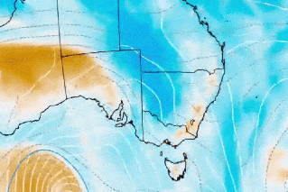
Source: Bureau of Meteorology
Flood warnings have been issued across western NSW as ex-Tropical Cyclone Kirrily brings dangerous downpours to a wide swathe of Australia.
Kirrily dumped drenching rain on western Queensland over the weekend, as it moved south along the Northern Territory border to NSW.
By Monday, its effects were expected to be felt in north-western NSW and north-eastern South Australia.
“The potential for dangerous flash flooding and damaging wind gusts is high, with flood watches in place as the system heads south-east into NSW over the next 24 to 48 hours,” forecaster Weatherzone wrote on Sunday.
“Fuelled by abundant tropical moisture, Kirrily’s trajectory is set to bring flooding rainfall to western, central, and south-eastern parts of NSW and eastern VIC on Monday.
“The impact is expected to contract to south-eastern NSW on Tuesday and Wednesday, posing a threat to the ACT, including Canberra, and densely populated areas south of Sydney.”
Tweet from @rftte
The weather bureau has issued flood warnings for many rivers in the region, for Monday and Tuesday.
“An inland trough is forecast to develop in north-west NSW during Monday as the remnants of Ex-Tropical Cyclone Kirrily move from Queensland. This trough may potentially bring significant rain to some western areas on Monday, before shifting to the south-east during Tuesday,” it said.
“Localised river level rises are likely within the areas of heaviest rainfall, with minor to moderate riverine flooding possible from Monday and into Tuesday.”
Weatherzone’s models predict widespread falls of 40-80 millimetres of rain in the area around the Queensland, NT and SA borders and stretching across NSW to the east.
“Some areas in the NSW interior may witness accumulations exceeding 200 millimetres by late Wednesday evening, with the bulk of the rainfall expected on Monday and Tuesday,” it said.
Six-hourly falls of more than 100 millimetres are also possible in these regions.
Tweet from @ACT_ESA
Bureau meteorologist Angus Hines said further falls of up to 50 millimetres were likely in Queensland as the ex-Tropical Cyclone Kirrily moved across Australia.
But he said brighter skies were on the way for Queensland, after Kirrily finally left the rain-battered sunshine state.
“On Monday, the whole system will move into northern NSW and should clear Queensland entirely through the day and not bring too much further rainfall there,” he said.
It would eventually cross the coast and clear away from Australia entirely about the end of Tuesday, he said.
Despite the relief, the full extent of Kirrily’s damage may not be known for some time as regions continue to face flooding.
Most major rivers across the interior and western Queensland had some level of flooding, Hines said.
“It can take a long time, often several days if not a couple of weeks, before the flood levels will completely subside,” he said.
The Flinders River faces major flooding while moderate flooding was possible at Burketown Airstrip on Monday as floodwaters moved downstream.
Roads have been cut, leaving road trains idle, rail networks are affected and properties have been inundated.
Mount Isa began restocking fresh produce only on Friday night, after trucks were able to access the town after being cut off for a week.
The relief might not last long as forecasters keep an eye on a tropical cyclone off the coast of New Caledonia, about 1500 kilometres from Queensland’s coast.
“We’re not forecasting it necessarily to be a direct hit on the country,” Hines said.
Strong, gusty winds and possible showers and storms could hit Queensland in the second half of this week even if the system does not cross the coast.
-with AAP
Want to see more stories from The New Daily in your Google search results?
- Click here to set The New Daily as a preferred source.
- Tick the box next to "The New Daily". That's it.