Multiple states on high alert as bushfire risk, temperatures, soar
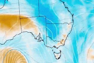
Source: Bureau of Meteorology
UPDATED
Multiple states are on high alert for bushfires with scorching conditions forecast ahead of the weekend.
The fire danger comes as Cyclone Jasper, which has intensified into a category four system, circles ever closer to Australia’s north-east coast.
Vast swathes of the country was under heat warnings early on Friday. Conditions are most alarming in South Australia, where a trifecta of dangerous weather conditions has prompted extreme to catastrophic danger alerts.
Tweet from @CFSAlerts
SA’s Country Fire Service has warned Friday would be “one of the most significant fire weather days in several years”. Across the border in NSW and Victoria, there are similar warnings ahead of a difficult day.
Temperatures are forecast to sore into the mid-40s in some parts of all three states, with strong winds and dry lightning adding to the fire risk.
The CFS has declared catastrophic fire danger ratings for the mid-north, Flinders, Yorke Peninsula, Riverland and eastern Eyre Peninsula districts.
Extreme fire danger ratings have been issued for SA’s Mount Lofty Ranges, north-east pastoral, west coast, upper south-east and Murraylands regions.
Any fires that did start would be “incredibly difficult” for firefighters to control, CFS chief officer Brett Loughlin said.
“The dry lightning creates a real risk of fire starting anywhere these thunderstorms occur, unfortunately the forecast is a broad area of dry lightning and thunderstorm activity,” he said on Thursday.
A Commonwealth large air tanker has been flown to SA to help with firefighting operations, but Loughlin said conditions could hamper its use.
“Forecast winds tomorrow are such that there is likely to be times when an aircraft will be unable to safely fly and fight fires,” he said.
“It is crucial that people do not rely on firefighters and aviation assets to save them.”
Residents were urged to have bushfire survival plans in place and to understand what they would do if there was an emergency.
Electricity outages are also possible as equipment is set to disconnect to minimise the risk of sparking a blaze.
“Those outages may also be extended in regional and remote areas if crews are stretched by managing safety in severe conditions and responding to the trifecta of weather conditions,” SA Power Networks corporate affairs head Paul Roberts said.
After Friday’s heat, temperatures will dip to the low to mid 20s across much of SA on Saturday. Adelaide is forecast to get up to 60 millimetres of rain over the weekend.
Tweet from @NSWRFS
In NSW, there are total fire ban in the lower central-west plains, southern Riverina, northern Riverina and south-western regions due to the heat. NSW residents will enter their third day of above-average temperatures on Friday, with the heatwave not expected to ease until next week.
There are also total fire bans for Victoria’s Wimmera and Mallee regions, with temperatures forecast to hit the low 40s.
Parts of Queensland, Western Australia, the Northern Territory and ACT have also copped soaring temperatures that are expected to intensify over the weekend.
Cyclone Jasper forces weather radar rethink
Meanwhile, the approaching Cyclone Jasper has prompted the Bureau of Meteorology to re-think weather radar upgrade plans in north Queensland.
Minister Mark Ryan and state disaster coordinator Deputy Commissioner Shane Chelepy were due to address media on preparedness for the event, from Kedron on Friday morning.
Cyclone Jasper has intensified into a category four system as it moves toward the Queensland coast, posing a looming threat to communities between Mackay and Cooktown.
The storm system is the first tropical cyclone to form in Queensland waters in December in an El Nino year.
Jasper was about 1250 kilometres east-north-east of Cairns at 4am (AEST) on Friday and moving south across the Coral Sea at 10km/h, the weather bureau said. Over the weekend, it is likely to weaken while also turning west towards the Queensland coast.
“While the timing of a coastal impact remains highly uncertain, the highest risk of a cyclone impact lies between Cooktown and Mackay, including Cairns and Townsville,” BOM said.
“As Jasper approaches the coast there is a risk of re-intensification and the potential for severe impacts.”
Senior meteorologist Laura Boekel has warned the coastal region directly hit by the cyclone may not be the only area affected.
“It may impact further away from where it is crossing,” she said on Thursday.
“We can see large impacts from tropical cyclones, especially when it comes to rainfall and flooding.”
She said potential cyclone affects included storm surges causing coastal flooding, damaging or destructive winds and heavy, widespread rainfall.
The bureau is issuing regular updates to keep communities informed.
-with AAP
Want to see more stories from The New Daily in your Google search results?
- Click here to set The New Daily as a preferred source.
- Tick the box next to "The New Daily". That's it.