Evacuations and flooding as deluge hits Sydney
A flood evacuation warning has been issued for low-lying areas of Woronora and Bonnet Bay, in southern Sydney, amid fears of significant flooding after an overnight deluge.
The NSW State Emergency Service has been door-knocking in the Sutherland Shire suburbs, warning residents to be prepared to leave the area on Thursday morning.
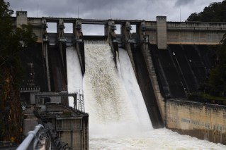
The SES has also warned of potential major flooding in Liverpool and Milperra in Sydney’s west along the Georges River, with water expected to rise above four metres in the late afternoon high tide.
“Residents of areas expecting to be flooded should make plans to leave when advised to do so. Ensure you take pets and valuables with you,” the SES said.
Tweet from @DaleDrinkwater
There were also reports of flash flooding on the Princes Highway in Kogarah, and a local aged-care home was evacuated after water entered the building.
There were also multiple flood warnings for rivers across NSW, with severe rainfall forecast to continue in the already-saturated state on Thursday.
NSW has been hit by repeated flooding in recent months, with the northern rivers area devastated by two deluges within weeks and Sydney drenched in its wettest March on record.
The Sydney has an annual average rainfall of 1213.4 millimetres but has already had 1223.8 millimetres in 2022 – with more to fall on Thursday and Friday.
There was a severe weather warning for southern and central NSW, metropolitan Sydney, the Illawarra, the south coast, the central and southern tablelands and parts of the Hunter on Thursday.
Severe thunderstorms were also predicted inland for the central-west slopes and plains near Parkes and the upper west near Cobar.
Heavy rain fell in the Illawarra, south coast and southern tablelands overnight and the wet weather was expected to extend across Sydney, the central tablelands and Hunter region on Thursday.
Six-hourly totals between 60 and 100 millimetres were forecast, with totals of up to 140 millimetres predicted on the coast.
Cronulla had 107 millimetres fall in three hours overnight.
Tweet from @NSWRFS
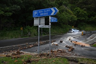
The Bureau of Meteorology has warned of an increased risk of landslides.
A flood watch has also been issued for central NSW, with minor to moderate flooding forecast for the southern coastal rivers, including the Hawkesbury-Nepean, the Macquarie and Queanbeyan rivers, on Thursday and Friday.
Minor flood warnings have been issued for the Hawkesbury River at Windsor and North Richmond and the Cooks River at Tempe Bridge and the Woronora River at Woronora Bridge.
Moderate flooding could occur on the Colo River at Putty Road.
SES Assistant Commissioner Dean Storey said on Thursday the SES had conducted 11 rescues and responded to almost 600 requests for help in the past 24 hours.
“We’re expecting those numbers to increase unfortunately today as that rain continues,” he told Nine’s Today program.
“It’s a very dynamic and volatile situation.”
Catchments were already soaked after months of heavy rain, the BOM said.
The bad weather is being driven by a strong upper trough over the centre of NSW, working to deepen another trough sitting off the coast.
The systems are expected to weaken on Friday morning.
“Heavy and persistent showers over the coming days will increase the chance of flash flooding and landslips over already saturated catchments,” BOM meteorologist Sarah Scully said.
Severe thunderstorms also pose a threat, including in northeast NSW.
“They may produce localised heavy falls [but] it is not expected to produce that riverine flooding,” Ms Scully said.
“Instead, it will be more localised flash flooding.”
-with AAP