Severe thunderstorm warning for much of NSW as Sydney swelters

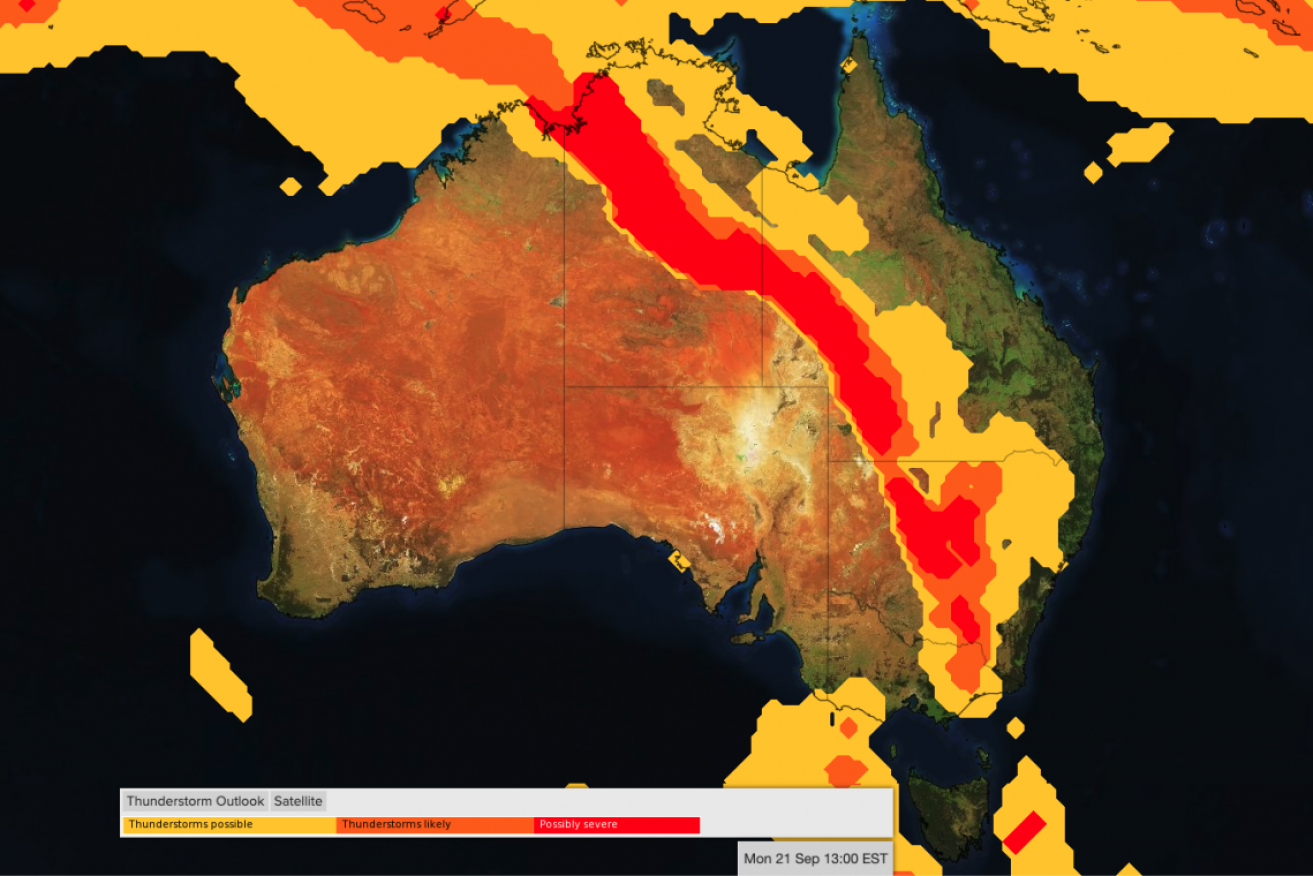
The thunderstorm outlook for early on Monday. Image: Weatherzone
Temperatures in Sydney hit 30 degrees early on Monday afternoon, ahead of forecast severe thunderstorms in parts of NSW and Canberra as a cold front moves through.
The broad area of thunderstorms was also forecast to hit parts of southern and western Queensland and central and eastern Victoria, brining damaging winds.
Tweet from @BOM_au
Weatherzone meteorologist Ben Domensino said the band of storms would extend more than 3000 kilometres from Victoria to the Top End.
“Some of these thunderstorms are going to become severe, with damaging to locally destructive wind gusts the main threat,” he said.
“Heavy rain and large hail are also possible, although generally less likely than dangerous winds because the storms will be fast-moving.”
The Bureau of Meteorology said the areas at greatest risk of severe thunderstorms included Bourke, Dubbo, Parkes, Wagga Wagga, Albury, Griffith and Canberra.

The area covered by the thunderstorm warning. Image: Bureau of Meteorology
Other areas that might be affected include Condobolin, Nyngan, West Wyalong, Narrandera, Cobar, Wanaaring, Brewarrina and Enngonia.
The storms could include destructive winds gusting to 120km/h – strong enough to bring down trees or powerlines. Large hailstones and heavy rain are also forecast.
A severe thunderstorm warning has been issued and further warnings are likely as the storms move east.
“A cold front is sweeping across inland NSW today, bringing strong and fast-moving storms,” the bureau said shortly before 3pm (AEST).
“Severe thunderstorms may produce damaging, locally destructive winds, large hailstones and heavy rainfall that may lead to flash flooding in the warning area over the next several hours.”
The 30-degree temperatures in Sydney on Monday are about eight-10 degrees above average for this time of year.
Thunderstorms are likely to continue on Tuesday and could affect parts of north-eastern NSW.
-with AAP
