‘Check for warnings’: Weather bureau sounds alarm as storms close in
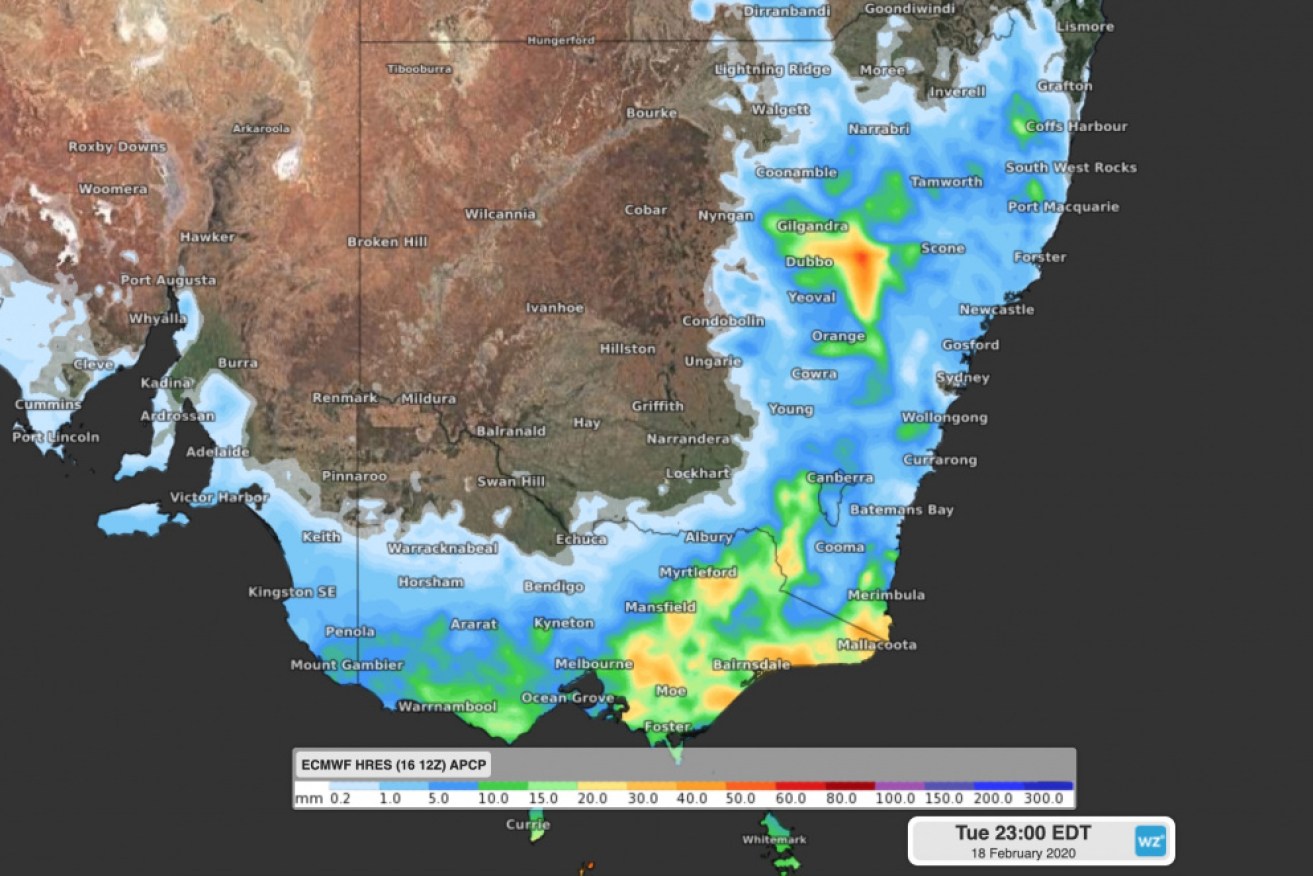
Rainfall predictions for Tuesday – although totals might be much higher in areas hit by thunderstorms. Photo: Weatherzone
Millions of people across NSW, Victoria and the ACT have been warned to prepare for dangerous thunderstorms on Tuesday.
Storms were already rolling across Melbourne on Tuesday afternoon, bringing flash flooding and heavy rain, mostly to south-eastern suburbs.
Later, the weather bureau issued a severe storm warning for Wollongong and areas south of Sydney.
“Severe thunderstorms beginning to develop and are likely to produce damaging winds in the warning area over the next several hours,” the Bureau of Meteorology said at 3pm (ADST).
“Locations which may be affected include Nowra, Bowral, Braidwood, Goulburn, Yass and Nerriga.”
It said more detailed thunderstorm warnings would be issued for Sydney and surrounds, and Canberra and Queanbeyan, if storms moved into those areas.
Weatherzone meteorologist Ben Domensino said a deepening low-pressure trough and low-pressure system would bring dangerous weather to much of south-eastern Australia.
“Storms are likely to develop over central and eastern Victoria and most of the eastern half of NSW, including the ACT but excluding the state’s far north-east,” he said.
“Severe thunderstorms are possible across this broad region, with damaging winds, large hail and heavy rain all a risk.”
Tweet from @samanthamaiden

Sighted in Canberra on Tuesday, ahead of forecast hail and thunderstorms. Photo: Facebook
Further south, similar weather is forecast across Victoria, particularly in the south and east.
“Melbourne, Canberra and Sydney are also at risk of severe storms, most likely in the afternoon or early evening,” Mr Domensino said.
BOM meteorologist Dean Narramore said severe storms were possible in Sydney and Canberra, but the main focus on Tuesday would be the Illawarra region and up towards the central coast.
“We could have some very dangerous thunderstorms there with very large hail, damaging winds and very heavy rainfall,” he said.
Check out the graphic to better understand what our thunderstorm forecast maps show. If storms do occur, warnings will be posted here: https://t.co/Fra4GA8hfw pic.twitter.com/DbAojRfqqW
— Bureau of Meteorology Australian Capital Territory (@BOM_ACT) February 18, 2020
Storms will hit NSW on Tuesday afternoon and stretch into the night. They could occur anywhere from the Victorian border to Queensland.
In Melbourne, the dangerous weather came earlier, with the first thundery downpours hitting late on Tuesday morning. More were forecast – bringing hail, heavy rain, and damaging winds – throughout the day.
Tweet from @BOM_Vic
Tweet from @VicStormChasers
In NSW, the weather bureau predicted falls of up to 50 millimetres in some places – while other areas might miss out altogether.
The storm activity will shift more to central and northern NSW on Wednesday, with the wet weather clearing later in the week.
But the recurring rain doesn’t mean the heat won’t return.
“We can get quite a few heatwaves and bursts of heat as we get into March,” Mr Narramore said.
Tuesday’s weather warnings come after Sydney experienced a weekend of wild weather earlier in February that filled dams and left thousands without power.
Melbourne also experienced damaging, isolated storms that flooded shopping centres and roads at peak hour last Friday.
-with AAP


