Cauldron of extreme heat developing in WA, heading for east coast bushfire zone
A build-up of intense heat that will raise temperatures in Western Australia into the mid-40s this weekend will be dragged across the country next week, right into parts of NSW and Queensland devastated by bushfires.
The NSW and Queensland bushfires have already burnt through more than a million hectares of land, killing four people and destroying more than 300 homes.
Bureau of Meteorology spokesman Neil Bennett said milder temperatures were expected to provide some relief to parts of NSW where fires continue to burn over the next few days, but the bushfire threat was far from over with the heat expected to ramp up again.
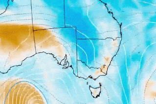
The areas in dark red on the map below show parts of WA will bake in temperatures above 45 degrees over the weekend, before the hot air mass bears down on the east coast by Tuesday.
“The problem that we have with the fires on the east coast is that there will be this break now … there are some cooler temperatures, but the heat from WA could push across over the course of the middle part of next week,” Mr Bennett said.
While early forecasts suggest areas in eastern parts of NSW and south-east Queensland will nudge 40 degrees by Tuesday, forecasters will keep a close eye on the winds to determine whether to issue fire weather warnings.
This week a catastrophic weather warning was introduced across large parts of NSW – the first time such a high warning has been issued since it was introduced in 2009 following the Black Saturday Victorian bushfires.
All the ingredients for fires, except one
Mr Bennett said wind strength could prove the key as to how bad conditions would get on the eastern seaboard next week.
“When you have fire weather conditions that are dangerous, you need a combination of a few things – you need to have high temperatures, you need strong winds, dry conditions, low humidity and you also need to have dry vegetation,” he said.
“The dry vegetation is there, if the air is coming across from WA it’s travelling over land so it’s dry, the temperatures are going to be warm, so all we then need to look at is what the winds are going to be like.
“If the winds start to pick up then we start to see a deterioration in the fire weather conditions as a result of that hot air starting to move across.”
On Tuesday the catastrophic fire warning was issued in part due to a strong cold front that brought a rapid wind change.
The WA cauldron
The extreme heat brewing in WA could mean November records tumble over the weekend.
“We are going to see a number of places away from the west coast getting very warm temperatures and in some parts approaching records for November,” Mr Bennett said.
“[It is] all because of a high pressure system that’s sitting in the bight that is going to direct hot north-easterly air over the region.”
Perth is in the midst of a hot spell, with a string of four days over 35 degrees expected – a phenomenon that has not happened in November since 1933.
The city will cool on Sunday as a trough along the west coast starts to move inland, pushing the heat to eastern parts of the state.
A maximum of 44 is forecast for Kalgoorlie on Sunday. That would topple the city’s current record of 43.7 degrees, reached on November 24, 1923.
The source of the blistering heat, which is being dragged across the southern half of WA and interstate, is the tropical north of WA, where monsoon rainfall activity is yet to begin.
“That’s something that will continue until we can get some relief in the form of any significant tropical activity,” Mr Bennett said.
“There’s nothing on the horizon for that, certainly over the next week, so we will probably get these very hot conditions on and off now until we can start to see the monsoon [trough] really building.
“[That] may not typically occur until middle to late December.”
Want to see more stories from The New Daily in your Google search results?
- Click here to set The New Daily as a preferred source.
- Tick the box next to "The New Daily". That's it.