Far north Queensland battens down ahead of cyclone warning
Residents have been warned to prepare for damaging winds and possible flooding. Photo: BoM
Far north Queensland residents are being urged to prepare emergency kits amid warnings that a potential New Year’s Day cyclone could bring damaging winds and torrential rain.
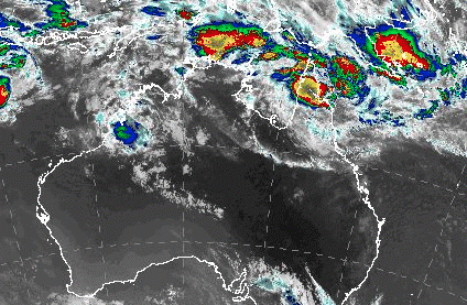
The Bureau of Meteorology says a monsoon trough in the far north is extremely active and the cyclone could develop near Cape York Peninsula as early as Monday night or January 1.
Forecasters are not yet sure how it will develop and where it will move, but the moist and unstable air mass will persist over the peninsula and the north-east tropical coast with showers, thunderstorms and some heavy falls possible.
There is a slight chance some of this will continue to the southern peninsula, the southern gulf coast and over the northern interior, but it is not certain.
A cyclone warning has been issued for a stretch of coast from Cape Keerweer to Cape York, taking in the communities of Weipa, Aurukun, and Mapoon.
A broader “watch” alert remains in place for people living in the area from Kowanyama up to the Torres Strait Islands.
Cyclone warning declared between #CapeYork and Cape Keerweer as a Tropical low continues to develop over the Gulf. A watch zone is also in place for remaining areas between #Kowanyama and Saibai Island, including adjacent inland areas. For info: https://t.co/5iKiGdZyzx pic.twitter.com/eXmwPfsTjN
— Bureau of Meteorology, Queensland (@BOM_Qld) December 30, 2018
The system is currently over the Gulf of Carpentaria and moving west but is expected to turn back towards the Queensland coast tomorrow.
“[It] is expected to intensify as it moves over Gulf of Carpentaria waters on Monday and, at this stage, it is rated a high chance of forming into a tropical cyclone on Tuesday,” a Bureau of Meteorology spokesperson told the ABC.
“People between Kowanyama and the Torres Strait Islands should consider what action they will need to take if the cyclone threat increases.”
Elsewhere in Queensland, it should be fine and mostly sunny for New Year’s Eve, with temperatures remaining above average in the west and southern interior.
Even if the far north residents are spared a tropical cyclone they are expected to face damaging winds and continued heavy rain.
The Queensland Emergency Services has advised north Queenslanders on Facebook that with rain and severe weather around, it was a good time to make sure their preparations were in order, such as emergency kits.
Emergency kits should include food and water, medical and sanitation supplies, a flashlight with extra batteries, battery powered or wind-up radio, fully charged mobile phone and charger, clothing and footwear, tools and supplies and important documents, QFES said.
Two people are missing in floodwaters.
The body of a yet-to-be-identified man was found on Monday morning, several kilometres downstream from where a 28-year-old man entered a flooded canal close to Cairns city on Saturday.
North of Cairns, there is still no sign of a 34-year-old woman last seen on Thursday walking into fast-flowing Wallaby Creek at Rossville.
Peak gusts of more than 90kmh are expected on Monday, with heavy rainfall expected to cause flooding over the coming days.
The system was over the Gulf of Carpentaria and moving west on Monday but expected to turn back towards the Queensland coast on New Year’s Day.
Meteorologist Jess Gardner said there was a greater than 50 per cent chance of it forming into a cyclone.
“We are expecting it to be a category two as it crosses back over the Queensland coast,” she said.
Tides are expected to heighten through the Torres Strait.
A flood watch remains current for coastal catchments north of Cardwell, including catchments across the Cape York Peninsula.
-with AAP