‘Very destructive’ Cyclone Ita set to slam coast
Cyclone Ita is set to hit Queensland’s far north today, with winds of up to 300km/hr threatening communities.
The Bureau of Meteorology warns the system poses a “serious threat” to communities along the far North Queensland Coast, with emergency service warning it is likely to destroy homes.
Winds of up to 125 km/h are set to batter the Queensland coast from late morning, with the centre of the storm set to his this afternoon.
It is expected to move southwest to south southwest and make landfall between Cape Melville and Cooktown late this afternoon or tonight.
MTSAT-2 early morning visible image of the eye of Cyclone Ita: http://t.co/c2ZUFkrwBl pic.twitter.com/1RXRkf2oKK
— Scott Bachmeier (@CIMSS_Satellite) April 10, 2014
The Bureau warns the coast will be hit by very destructive winds to 300 kilometres per hour near the core and gales extending out to 200 kilometres from the centre.
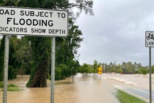
As it approaches land, it is pushing a “wall of water” ahead of its 80km wide core.
The bureau says while intense, Ita is a smaller and slower system than 2011’s Cyclone Yasi.
Cook Shire Mayor Peter Scott told the Brisbane Times the cyclone was coming in “faster and bigger” than they first thought.
Locals and tourists spent last night in the Cooktown cyclone shelter, which opened earlier when the storm was upgraded.
Emergency services have recommended people secure their homes, have food and water, charge phones and evacuate to a shelter early.
Premier Campbell Newman toured Cooktown and Hope Vale as the Cyclone bore down on the state.
Locals are waiting for the storm to hit.
Eerily calm at Cairns harbour as monster Cat 5 Cyclone Ita heads this way. Live with more details soon @TheTodayShow pic.twitter.com/s2b1lX5LCw
— Joel Dry (@JoelDry9) April 10, 2014