Flood-hit regions prepare for heavy rain, wild winds as cyclone watch issued

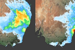
Source: Bureau of Meteorology
Flood-hit regions have been placed on cyclone watch as the season’s third threat in as many months looms.
A tropical low in the Gulf of Carpentaria could develop into a cyclone as soon as overnight Thursday or during Friday.
Towns on both sides of the Queensland-Northern Territory border have been warned to brace for 100km/h winds and intense rainfall of up to 200 millimetres.
“Even if it doesn’t develop into a tropical cyclone, parts of the Gulf of Carpentaria coast could experience strong to gale force winds and heavy rainfall.”
The slow-moving tropical low prompted a cyclone watch to be issued by the Bureau of Meteorology late on Wednesday.
The cyclone watch area spans from the NT’s Port Roper to Burketown in Queensland’s north-west.
Tweet from @BOM_Qld
On Thursday morning, the weather bureau said there was an “increasing risk” of the tropical low becoming a cyclone.
“We do expect with the favourable conditions in the Gulf of Carpentaria that that system could develop into a tropical cyclone,” a spokesperson said.
It would be the third cyclone of the season to hit Queensland.
On Friday the system is likely to move south-west to the Gulf coast and then on Saturday be inland and weakening.
Over the weekend and next week it is expected to move west over central NT and then northern Western Australia, “bringing heavy rainfall to areas near its path”.
There is a chance it could strengthen again into a cyclone when reaching waters west of the Kimberley by next Wednesday.
Weatherzone said warmer than normal sea surface temperatures were feeding moisture into the low.
“This length of time the low will spend over water increases the risk of the system developing into a tropical cyclone on Thursday and Friday,” the forecaster said.
Flood-battered towns
The Gulf region is already reeling from flooding caused by ex-cyclone Kirrily, which crossed the Queensland coast just weeks ago before lingering in the north-west.
In mid-December, Tropical Cyclone Jasper caused record flooding and forced a community to evacuate when it made landfall as a category two system north of Cairns.
There has already been widespread rainfalls of up to 100 millimetres in the NT’s north-west over the past three days.
In Queensland, the inundated Gulf region has been further hit by heavy falls with Georgetown copping 100 millimetres and Burketown more than 70 millimetres in the past 24 hours.
“There is a risk of severe weather happening regardless of whether it develops into a tropical cyclone,” the bureau spokesperson said.
“In Queensland this may further exacerbate flooding that is already occurring.”
People in the watch zone have been urged to be prepared and keep up to date with alerts.
In Queensland, the system looks set to add to an already long list of recent natural disasters that have blown the state’s repair bill beyond $1 billion.
Hardship payments are still being made available in the wake of Kirrily, with primary producers in 15 local government areas able to apply for loans up to $250,000.
Overall, 32 local governments across Queensland have been activated for recovery assistance.
In the far north, the clean-up continues after Cyclone Jasper, with Queensland Rail crews working hard to reinstate services.
The popular Kuranda Scenic Railway will reopen on Saturday. But further work to “future-proof” the track is expected to continue until July.
Queensland’s tourism industry is also trying to recover with Virgin Australia releasing more than 300,000 sale fares over seven days from Wednesday.
Tourism and Events Queensland is also offering more than 500 deals on accommodation, attractions and experiences.
-with AAP


