Severe warning as storm band covers three states
Source: Bureau of Meteorology
Severe thunderstorms are expected to hit Victoria’s east on Wednesday afternoon as part of a wider band of stormy weather stretching across three states.
A warning has been issued for severe thunderstorms capable of producing heavy rainfall in East Gippsland, North East, West and South Gippsland Forecast Districts.
The thunderstorms are headed for central Victoria before becoming widespread over the eastern half of the state.
There is potential for heavy falls, large hail and damaging winds, the Bureau of Meteorology says.
Melbourne can expect showers and likely a thunderstorm, possibly severe.
It’s part of a broader thunderstorm risk that extends inland from Sydney to the far west of Victoria and much of Tasmania as well.
“Storms are possible through all of these areas through Wednesday afternoon-evening, but in particular the risk of severe thunderstorms is around the Victoria-NSW border,” said senior meteorologist Angus Hines.
“Severe thunderstorms are storms which get large enough to generate any of the following — heavy to intense rainfall, damaging to destructive winds gusts, and large to giant hail.
“And that is possible in these areas but in particular the far east of Victoria around Gippsland, the far southeast of NSW around the Snowy Mountains, and the South Coast forecast district.”
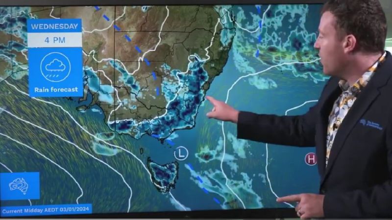
Meteorologist Angus Hines points out a band of rain expected over Victoria, NSW and Tasmania. Photo: Bureau of Meteorology
On Thursday the thunderstorm band is expected to slide northwards “just a little bit”.
“In general for Thursday thunderstorms become most likely around southern and central NSW, maybe just the far northeast of Victoria as well but generally a north-eastward movement to the thunderstorm risk for tomorrow.”
Vic storm chaos
On Tuesday evening, thunderstorms brought heavy rain, damaging winds and large hail to parts of Victoria.
Weatherzone.com said a wind gust of 104 km/h was recorded at Wangaratta, large hail fell in Bendigo and 26 millimetres of rain poured in 10 minutes at Coldstream.
There were around 40,000 lightning strikes, and flights were disrupted at the Melbourne’s airport.
Almost 50,000 homes and businesses across the state were without power.
One of the state’s major energy providers, Powercor, said it was still working to reconnect power to 2400 homes.
Most are expected to have power restored on Wednesday but Powercor said it was likely some properties would remain without power overnight.
There were 7600 customers with AusNet, supplies power to power to all the state’s east, southeast and much of the north, still without power on Wednesday afternoon.
Police have urged people not to drive in floodwaters after a man and his dog were swept away in fast-moving water in the state’s north.
The 60-year-old man had driven into floodwaters on Tuesday and was rescued by emergency services. He was taken to hospital for observation and escaped injury.
Tweet from @9NewsMelb
Meanwhile in Queensland, the bureau said the worst of the wild weather has moved, but isolated showers and thunderstorms were likely across most of the state on Wednesday.
Australian Defence Force troops have been deployed across the state to help with recovery efforts while authorities continue work to restore power to about 8000 homes.
Authorities were hoping to get power restored by Friday but Queensland Police Assistant Commissioner Ben Marcus said it’s more likely to be completed at the weekend.
“That’s effectively because we lost a couple of days due to wet weather,” he said.
“We’re not talking one or two power poles, we’re talking hundreds and hundreds so it will take quite a long time to restore that.”
There are about 15,000 NBN services offline, mostly related to the power outages.
Federal Emergency Management Minister Murray Watt said compounding weather events meant the state needed more resources.
“But when we had that heavy rainfall hit as well, to compound the situation, that’s when the Defence Force was really needed.”
Hundreds of flood-damaged Queensland roads remain closed and continuing rain means an increased potential for landslides and fallen debris.
Dozens of people have been rescued from flood waters, with the SES responding to more than 5000 calls for help since Christmas Day.
Ten homes in the southeast have been destroyed by storms with 386 copping minor and 145 moderate damage.
Storms and flooding in northern NSW have also kept emergency services working overtime.
A cluster of localities received more than a month’s worth of rain in the 48 hours to Tuesday evening, some centres in the Northern Rivers region copping falls of more than 500mm.
The SES said local crews had completed 28 rescues during the period.
In response to criticism of the bureau for its forecasts during Cyclone Jasper in December, Senator Watt said updates and warnings were provided in the lead-up to flooding and storms but it was hoped to improve emergency text alerts more generally sent out by councils.
“There was a bit of a gap between some of the information the bureau
-with AAP