BOM declares La Nina alert, with 70 per cent chance of forming in 2020
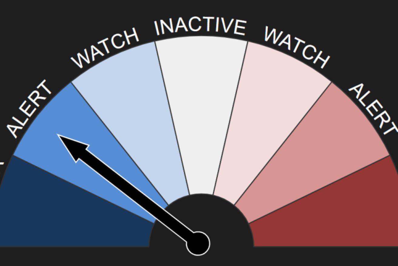
BOM's ENSO outlook has moved to a La Nina alert. Graphic: Bureau Of Meteorology
The odds of a La Nina in the coming months have improved to a 70 per cent chance – roughly three times the normal likelihood – and it’s not the only climate driver that could potentially favour wet conditions heading into spring.
Bureau of Meteorology (BOM) climatologist Naomi Benger said La Nina could mean a few different things for the Australian region.
“One of them is enhanced rainfall for central, eastern and northern Australia,” she said.
“So while some areas might welcome that bit of extra rain if they’ve been in drought, it can lead to an elevated risk of flooding.”
La Nina events are also associated with heightened risk of cyclones as well as cool daytime temperatures.
“There is generally more cloud and more soil moisture, which means the daytime temperatures could be a little bit lower on average,” Dr Benger said.
La Ninas are typically wet, but …
Weather nerds with good memories will recall a La Nina was declared in 2017 and, rather than bringing widespread rains, it was the beginning of the latest drought.
Dr Benger said that La Nina did not last long enough for the impacts to really manifest.
“The last significant La Nina event was in 2010-11, and that was Australia’s wettest two-year period on record,” she said.

When there is a La Nina, the Walker circulation intensifies, bringing wet and warm conditions to Australia. Graphic: BOM
Many will remember that summer for widespread flooding along the east coast, including the worst floods in Brisbane since 1974.
So are we looking at a 2017-18 or a 2010-11 kind of event?
Dr Benger said it was difficult to say at this stage, and the BOM’s announcement did not guarantee Australia will reach La Nina thresholds this year.
“At the moment there’s a 70 per cent chance of it developing, but really how it manifests will depend on the other climate drivers as well.”
The other climate drivers
Over the past few years, the positive phase of the Indian Ocean Dipole (IOD) has been dominant, bringing dry conditions to eastern Australia.
This year, however, it looks like that could change.
“The IOD has been quite tricky this autumn-winter period to predict, but at the moment, three of the six models that the BOM surveys are indicating that a negative IOD could develop during spring,” Dr Benger said.
A negative IOD favours wetter-than-average conditions for Australia – but some of the models are indicating a more neutral IOD in the coming months.
“We are certainly not as confident in that as we are with the La Nina,” Dr Benger said.
But at least it currently looks unlikely we will be facing another strong positive IOD.
Then, of course, there are other drivers, like the Southern Annular Mode (SAM).
Dr Benger said while the SAM operated on a shorter time period, it would affect how far north or south frontal systems to the south of Australia moved and how far south rain-bearing systems came along the east coast.
“So that will also play into when and where we get rainfall.”
Speaking of cold fronts, a series of fronts and troughs is expected to bring strong winds, rain, hail, snow and below-average temperatures for the south-east of the country over the coming days.
As usual, check the warnings with the BOM or your local ABC emergency broadcaster on Facebook or radio and heed the advice of your local emergency services.
Our #ENSO Outlook has moved to #LaNiña ALERT. This means there's around a 70% chance of La Niña developing in 2020—around 3 x the usual chance.
So, what signals are we seeing in our oceans and the atmosphere, and what could La Niña mean for Australia? https://t.co/xQ0C6yIWwo pic.twitter.com/D5YccN9em8
— Bureau of Meteorology, Australia (@BOM_au) August 18, 2020
Want to see more stories from The New Daily in your Google search results?
- Click here to set The New Daily as a preferred source.
- Tick the box next to "The New Daily". That's it.

Labor elder warns of authoritarianism